


What we are doing - Berkshire LNP
Responses sent from the LNP will be posted online here:
Bracknell Forest Council Local Plan - October 2019
Royal Borough of Windsor & Maidenhead Local Plan - Jan 2017
Airports Commission Third Runway - Feb 2015
Thames Valley Berkshire Local Enterprise Partnership's Strategic Economic Plan - Feb 2014
Defra's Request for Views on Data Requirements - Feb 2014
EA Challenges and Choices - Dec 2013
Common Agricultural Policy (CAP) Implimentation - Nov 2013
Biodiversity Offsetting - Oct 2013
Defra's new Wildife Guidance - Sept 2013
Improving Reading Woodlands - Sept 2013
The report 'Making Space for Nature' tells us that we need to chance our current approach to nature conservation, from simply trying to protect what we have to a large scale approach which re-establishes habitat networks and the services they provide us. Habitat networks are an effective method of conserving nature in landscapes that have been fragmented by human actions; they ensure that core sites for wildlife are connected, and that gene flow between populations is maintained.
In order to take this approach in Berkshire, and work towards joining-up our habitats across the landscape, it is important to have a good understanding of the current functional connectivity of our main habitat types.
Berkshire's Biodiversity Action Plan Partnership identified Biodiversity Opportunity Areas as the first step in improving habitat connectivity in the county. Areas were identified based on existing concentrations of habitat and important areas for rare species, as well as considering land with the potential for habitat restoration and other factors (such as geology, topography and hydrology).
Mapping Habitat Connectivity in Berkshire
We undertook a project to look at current functional habitat connectivity in the county. This project collaborated with the University of Reading and the Berkshire, Buckinghamshire and Oxfordshire Wildlife Trust.
Aims of this project
The project aims to improve our understanding of habitat connectivity in Berkshire in order to help to identify where habitat restoration may be best situated to provide the biggest gains for biodiversity, and to identify a way to track changes in habitat connectivity in the county over time.
Project Outputs
The project outputs include 4 maps, showing current habitat networks (functionally connected habitats) for each of the four broad habitat types within the county; woodland, grassland, heathland and wetland, based on a least cost model.
It is also possible to re-run the model, asking specific questions that may occur at a local level. For example, experts in specific species may wish to investigate how connected the landscape is for that particular species or someone writing a land management plan may wish to look at which habitats it would be best to (re)create to improve connectivity in the area. For further information about the project outputs, or to re-run the models with different parameters, please contact the LNP.
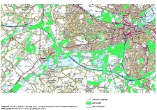
Picture 1. Example of grassland connectivity near Reading
Summary of Method
Stage 1: Creating a Land Use Map for Berkshire
We obtained land use maps from the Thames Valley Environmental Records Centre (TVERC). Ordinance Survey VectorMap District data was combined with this data set in order to map roads and buildings. The result is a map layer with 100% coverage of Berkshire, showing land use.
A fee may apply for the provision of this data.
Stage 2: Assigning Costs
The model that we decided to use requires estimates to be made regarding how well species typical of one habitat type can move through other land use types. For example, how well a typical woodland species could travel through grassland, roads, built areas, wetland etc.
There was a national project led by Roger Catchpole, Natural England looking at national habitat networks. As part of this project work was done to collate information about habitat permeability for generic woodland, heathland, grassland and wetland (fen, mire, bog) species. This project produced the relative costs for each generic species to travel through each land use type. For example, a typical woodland species may be able to travel 3km through broadleaved and mixed woodland, but only 10m across a motorway, or 300m across grassland habitats.
We used these 'costs', adapted slightly to account for local variation.
Stage 3: Running the model
We used the cost-distance tool in ArcMap to produce the final maps. The model looks at each location (grid square), and calculates the least cost option for retuning to optimal habitat from that square in Berkshire. Essentially this highlights which bits of habitat in Berkshire are functionally connected for typical species of each of the four broad habitat types (woodland, grassland, heathland and wetland).
Further Information
Full details of the method and associated limitations can be obtained by contacting the Berkshire LNP.
More information can also be obtained from:
Catchpole, R. (2007) England Habitat Network Briefing Note, Natural England
Catchpole, R.D.J. 2006. Planning for Biodiversity – opportunity mapping and habitat networks in practice: a technical guide. English Nature Research Reports, No 687
The Trent Valley Biodiversity Opportunity Mapping Project by Nottingham Biodiversity Action Group
There are 29 Biodiversity Opportunity Areas (BOAs) in Berkshire - these make up a total area of 48,112 hectares!
Conservation need outweighs available funding. BOAs identify where the greatest opportunities for habitat creation and restoration lie, enabling the efficient focusing of resources to where they will have the greatest positive conservation impact. This will represent a more efficient way of delivering action on the ground.

Click here for a larger version of the map.
BOAs will have multiple benefits: improving the natural environment and providing quality areas in which people want to live and work. A wide range of organisations and individuals will have a role to play in making the ecological network a reality.
See the links on the right for information on the individual BOAs.
Why Biodiversity Opportunity Areas?
Traditionally, nature conservation has focused on protecting important sites. This approach has achieved a lot however it, alone, cannot sustain biodiversity in the long-term. Many once common species are still in decline. Important sites are still fragmented and isolated from one another. In order to successfully conserve a viable natural environment, we also need to take into account physical factors such as water and nutrient cycling. These processes link sites to the wider landscape and affect the habitat found. In other words, we need to reconnect biodiversity with ecosystems, and change the scale of work towards a landscape focus.
Landscape-scale conservation reconciles protection of habitats and species of principal importance with ecosystem function. It allows us to adopt a more sustainable approach to custody of the countryside; ensuring biodiversity can adapt and thrive in the face of climate change. To achieve this, opportunities must be sought to expand, link and buffer sites. We need to increase the quality of the entire countryside for wildlife. This will begin to reverse the current fragmented picture of ecosystems, and enable us to reclaim a healthy and functional environment. This change is also vital to safeguard our own quality of life, as we are dependent on natural services such as climate regulation and food production.
How were the BOAs selected?
The identification of Berkshire's BOAs was a detailed assessment process. It took into account existing concentrations of habitat, important areas for rare species of principal importance, land with potential for habitat restoration, and several other factors (including geology, topography and hydrology). Many of the areas identified are well known in Berkshire for their nature conservation importance and they all contain principal habitat.
The work was funded by all Berkshire's Unitary Authorities and was undertaken by Thames Valley Environmental Records Centre (TVERC). For further details about the selection process, please contact TVERC.
Inside a Biodiversity Opportunity Area
BOAs do not represent a statutory designation or a constraint upon activities. They indicate areas where there are substantial opportunities to make positive changes for biodiversity, and should be used to inform conservation strategies and place planning. Members of Berks LNP will strive to work with farmers, landowners, planners, developers and communities in these areas and aim to show that in partnership we can achieve social and economic objectives alongside a thriving natural environment. The Berkshire targets will be linked to BOAs wherever possible to increase the effectiveness of our work.
Outside a Biodiversity Opportunity Area
BOAs are a means of indicating where significant gains can be made for biodiversity. They do not contain all habitat of principal importance or all the areas where habitat creation or restoration is possible throughout Berkshire.
Whilst they are useful in directing conservation effort, they are not the only areas where biodiversity work can be delivered. Everyone has a role to play in conservation and you should not feel discouraged to find you are not within a BOA. If you would like information or ideas about other local opportunities, please contact us.
Future work...
We will regularly review the current activities and support within BOAs. This will enable identification of any gaps in provision and opportunities for progressing existing work. The review will also help to identify potential projects to secure the specific objectives within each BOA.
Draft Agenda for BLNP Conference on 28th September 2013
'A Shared Vision for Biodiversity'
9am to 12pm – TVERC Recording Conference:
Berkshire & South Buckinghamshire Bat Group. (Bridget Parslow) - What the group have been doing and plan to do going forward.
Wokingham District Veteran Tree Association. (Barbara Stagles):. Veteran tree surveys focusing on how the survey material has been used for to bring about changes in attitude and practice regarding veteran trees.
Berkshire Mammal Group. (Laura Daniells) - About the group, aims and work to date.
TVERC.(Helen Miller) - What's been seen 2012-2013 and what happens to records.
12pm to 1pm – LUNCH – a light lunch provided.
1pm to 4.30pm – The Local Nature Partnership:
1pm – Welcome & Introduction (15mins)
1.15pm –; The LNP and what it can do for nature in Berkshire by Andrew Cameron (To include recent developments and launch of new website) (30 mins)
1.50pm –Biodiversity Opportunity Areas – a strategy for delivery by Matt Jackson (Background to BOAs, next steps, invitation to become 'leads') (30 mins)
2.25pm –Case study demonstrating the benefits of nature; Fobney Island by Graham,Scholey (30 mins)
2.55pm – Explanation of Workshop session (5 mins)
3pm - BREAK (30 mins)
3.30pm – Split into groups to discuss one of the topics below (45mins)
a) How we can aid the delivery of the Berkshire Biodiversity Opportunity Areas on the ground.
b) Biodiversity Offsetting in Berkshire
c) Engaging businesses in nature conservation.
Include a brief summing up by the facilitator to each group. Comments to be collated and posted on LNP website.
4.15 to 4.30pm – Finish and close
The Berkshire Local Nature Partnership will assist England in achieving its target of halting the loss to our biodiversity (nature), by working at a local level to identify and implement opportunities to protect our natural environment. The Berkshire Biodiversity Strategy incorporates aspects of targets from the England Biodiversity strategy, which we can achieve here in Berkshire.
The Berkshire Biodiversity Strategy
The Natural Environment in Berkshire: Biodiversity Strategy 2014 - 2020 is available to download now by clicking here.
This report is both a statement of the current state of nature in Berkshire and a strategy for protecting and enhancing our natural environment.
You can help us in recording Berkshire progress towards these targets by keeping us informed of any nature conservation work that you carry out in the county.
England Biodiversity Strategy:
History
The UK Biodiversity Action Plan (BAP) was the UK national biodiversity strategy, prepared in response to the Earth Summit and the Convention on Biological Diversity (CBD) in 1992. Part of it was a description of the UK biological resources and an outline of how to conserve them.
UK BAP priority species and habitats were identified as those that were the most threatened and required conservation action. The original lists of UK BAP priority species and habitats were created between 1995-1999, and subsequently updated in 2007.
As biodiversity policies have evolved at a national and international level and following devolution in 1998, priorities have shifted away from the UK BAP. England biodiversity strategy is now set out in Biodiversity 2020: A strategy for Englands wildlife and ecosystem services, which was published by Defra in August 2011.
Targets
Four areas are targeted for action in the Strategy in order to halt the loss of England biodiversity by 2020 and to contribute to international commitments. These are:
• A more integrated large-scale approach to conservation on land and at sea;
• Putting people at the heart of biodiversity policy;
• Reducing environmental pressures; and
• Improving our knowledge.
Although national priorities have developed and shifted away from the UK BAP, the focus on certain species and habitats remains. The UK BAP lists of priority species and habitats were used to draw up the Section 41 list of species and habitats of principal importance in England.